Why Traditional Navigation Tools Fall Short on Trails
Trail running takes you deep into nature, often far from well-trodden paths and reliable infrastructure. While classic navigation methods have served adventurers for centuries, the unique demands of moving quickly and efficiently over varied terrain highlight their limitations compared to modern wearable technology like a watch equipped with topographical maps.
One of the most common tools people rely on today is the smartphone 📱. While incredibly powerful and versatile, your phone faces significant challenges in remote backcountry environments. Battery life 🔋 can drain rapidly, especially when actively using GPS and maps, potentially leaving you without navigation or communication capabilities when they are needed most. Signal reliability is also a major concern; deep canyons, dense tree cover, or remote valleys can render your phone’s GPS inaccurate or completely useless. Furthermore, screens can be difficult to see in bright sunlight or when wet, and the device itself is vulnerable to drops, impacts, or water damage – a constant risk when navigating technical trails.
Traditional paper maps 🗺️ and compasses 🧭 are invaluable skills and essential backups, but they too have drawbacks specifically for the dynamic environment of trail running. **Paper maps** are highly vulnerable to the elements; rain, sweat, or even just damp conditions can quickly make them illegible or cause them to tear. Unfolding and refolding a large map while trying to maintain your running pace or on a windy ridge is cumbersome and distracting, breaking your flow and potentially leading to mistakes. They provide a static snapshot of the terrain but lack real-time updates on your precise location without manual triangulation, a skill that requires stopping and focusing intently.
Trying to make quick pace adjustments or check your position frequently using analog tools like a paper map and compass can significantly slow you down. The process of orienting the map, taking bearings, and identifying landmarks requires you to stop or move very slowly, which is counterproductive when trying to cover distance efficiently. You don’t get instant confirmation of whether you’re on the right track or how much elevation gain is left. For the focused intensity of a trail run, you need information that’s immediately accessible and easily digestible without breaking stride or losing momentum, capabilities where traditional methods often fall short.
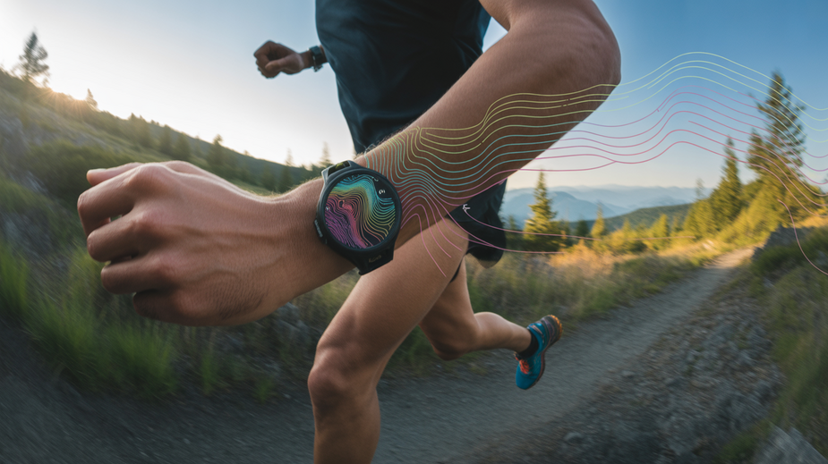
Decoding Watch-Based Topo Maps: Key Features
Navigating the wilderness with a tiny screen on your wrist might seem daunting, but modern trail watches pack powerful topographic mapping capabilities. Understanding the key features displayed on these maps is crucial for effective navigation during your backcountry runs. Unlike basic breadcrumb trails, these maps offer rich geographical detail right at your fingertips.
One of the most fundamental elements on a topographic map is contour lines ⛰️. These lines connect points of equal elevation. When contour lines are close together, it indicates a steep slope. If they are far apart, the terrain is more gradual. Learning to read the patterns of these lines allows you to visualize the shape of the land – where hills rise, valleys dip, and ridges run. Coupled with elevation data, you can anticipate climbs and descents, helping you manage your effort and plan your route efficiently. Most watches display spot elevations for peaks, saddles, and other significant points, further aiding your understanding of the vertical landscape.
Beyond elevation, these maps pinpoint crucial navigational aids. You’ll see water sources 💧 like rivers, streams, and lakes, which are vital for refilling water bottles or identifying landmarks. Trail junctions are clearly marked, showing where different paths intersect. This is invaluable for confirming you’re on the right trail or planning redirects. Look for symbols indicating points of interest, shelters, or even potential hazards like cliffs, depending on the map data loaded onto your device. Familiarizing yourself with the standard symbols used on your watch’s maps before you head out is highly recommended.
While powerful, continuous display of detailed maps can quickly drain battery life, especially on extended runs. Most watches offer battery-saving display customization 🔋 options. This might include reducing screen brightness, limiting how often the map refreshes, or setting the display to turn off after a few seconds of inactivity, only waking up when you raise your wrist or press a button. Some devices allow you to toggle between full-color maps and a simpler, less power-hungry black-and-white mode. Experiment with these settings during shorter runs to find a balance between usability and battery longevity that suits your typical run duration. Understanding and utilizing these features transforms your watch from a simple tracker into a capable, on-wrist navigation tool.
Pre-Run Setup: Optimizing Your Watch for Wilderness
Before you even step onto the trail, dedicating time to properly configure your GPS watch is non-negotiable for a safe and effective wilderness run. Unlike navigating city streets where signal is plentiful, remote backcountry demands proactive preparation. Getting your watch set up correctly at home ensures it’s a reliable tool, not a frustrating liability, when you’re miles from civilization. This setup covers everything from ensuring you have the right maps to preparing for potential emergencies.
One of the most critical steps is downloading offline maps 🗺️ for your intended route and surrounding areas. Remote locations often lack cellular service, rendering online maps useless. Your watch needs to have the topological data stored locally. Most modern outdoor watches require you to download these maps via their connected smartphone app or desktop software before you leave an internet connection. Always download a larger area than you think you’ll need – diversions or unexpected turns happen. Check your watch manufacturer’s specific instructions, as the process can vary between brands like Garmin, Coros, Suunto, or Apple Watch Ultra.
Equally important for safety is setting emergency waypoints and enabling breadcrumbs 📍. Waypoints are digital markers you place on specific locations – the trailhead, your car, a planned water source, or even a potential emergency shelter marked on a map. These are fixed points you can navigate back to. Enabling the breadcrumb or track-back feature is vital; it records your exact path as you move. If you get disoriented, you can simply follow the breadcrumbs back the way you came. Familiarize yourself with how to drop a quick waypoint and how to activate the track-back function on your specific watch model *before* you’re in a stressful situation.
Accurate navigation also relies heavily on correct altitude data, making calibrating altitude sensors accurately ⛰️ a key pre-run task. Barometric altimeters on watches are affected by weather changes. While GPS provides altitude, barometric data is often more precise for tracking ascents/descents on a specific route profile. Most watches allow calibration via GPS (using your current GPS position to set altitude), manual input (entering altitude from a known point like a trailhead sign or map), or using a digital elevation model. Calibrating at the trailhead or another known elevation point is highly recommended for the most reliable data during your run. Learn more about how watch altimeters work.
Here are the key setup actions summarized:
- Download offline topo maps for your route and surrounding region.
- Identify and set emergency waypoints (trailhead, car, key junctions).
- Ensure breadcrumb or track-back recording is enabled.
- Calibrate your watch’s altimeter at a known elevation point.
Taking these steps ensures your wrist-based navigation tool is fully prepared to support you, providing critical data and safety features when you’re deep in the wilderness. It’s a small time investment upfront that pays dividends in confidence and security during your run.
(Embed a relevant video here, e.g., a guide to setting up maps on a specific watch brand)
Real-Time Navigation Strategies Mid-Run
Okay, you’ve done the crucial prep work: downloading maps, setting waypoints, and calibrating sensors. Now you’re out on the trail, and the real test begins – *real-time navigation* using your watch. This phase is dynamic, requiring you to interpret data on the move and react to the environment and your physical state. Your watch transforms from a planning tool into an active guide on your wrist.
One of the most valuable tools available during your run is the ability to track your progress against the *elevation profile* 📈 of your planned route. As you ascend or descend, your watch updates your position on this graphic display, showing exactly where you are relative to upcoming climbs, descents, and plateaus. This visual feedback is incredibly powerful for managing your effort. Seeing a significant uphill section approaching allows you to conserve energy, while knowing a long downhill is next can influence hydration or fueling decisions. It helps you break down the run into manageable segments based on terrain.
While GPS is your primary locator, conditions like dense tree cover, steep canyons, or sudden heavy rain and clouds can occasionally impact signal strength or accuracy. This is where your watch’s reliable *compass mode* 🧭 becomes essential. Unlike the map that shows your location, the compass provides your precise *direction of travel*. If visibility suddenly drops due to fog or a squall, or you need to quickly orient yourself off-trail to bypass an obstacle, the compass provides an unwavering bearing to keep you pointed in the correct direction, adding a critical layer of safety and confidence when the visual cues disappear.
Effective wilderness navigation isn’t solely about knowing *where* you are geographically, but also managing *how* you traverse the distance. Many modern trail watches integrate navigation with performance features like *pacing alerts*. These can be set to notify you if you drop below or exceed a target pace, remind you to fuel or hydrate, or keep you within a specific heart rate zone. While these might seem like pure performance metrics, they are vital navigation aids on longer runs. Maintaining a sustainable effort prevents premature fatigue, ensuring you have the physical and mental capacity needed to navigate complex sections and make sound decisions throughout your adventure. Combining awareness of elevation, directional bearing, and your own physical state is key to successful real-time navigation.
Advanced Techniques for Route Finding
Moving beyond simply following a pre-planned route, modern GPS watches offer sophisticated tools that allow backcountry runners to engage in more dynamic and strategic navigation. Mastering these advanced techniques can unlock new possibilities for exploration and significantly enhance safety on challenging runs.
One powerful technique is creating custom routes integrated with heatmap overlays 🔥. Heatmaps visualize popular trails and routes based on aggregated user activity. By overlaying this data on your map, you can identify established paths you might not otherwise know about, or conversely, spot areas with less traffic if you’re seeking solitude. Drawing your own route directly on the watch or its companion app, informed by these heatmaps and the underlying topography, allows for truly personalized exploration, letting you craft the perfect blend of challenging climbs and runnable sections.
For terrain requiring more than just following a line, such as off-trail sections or scrambles, utilizing 3D map rotation is invaluable. Traditional 2D maps can sometimes flatten the reality of steep slopes and complex geological features. By rotating and tilting the map view, you gain a much clearer perspective of the terrain’s three-dimensional structure, helping you visualize lines of ascent or descent, identify potential obstacles, and navigate technical sections with greater confidence and situational awareness.
Finally, a crucial aspect of advanced backcountry navigation is the ability to quickly identify safe bailout points 🆘. Even with meticulous planning, conditions can change, or you might encounter unexpected challenges that necessitate altering your route or exiting the wilderness. Being able to rapidly scan your watch’s map to locate the nearest trail, road, or area of lower elevation that offers a safe and efficient escape route is paramount for safety and risk management. Your watch becomes not just a navigation tool, but a critical lifeline for dynamic decision-making in remote environments.
Safety Protocols When Tech Fails
Even the most advanced GPS watches aren’t foolproof in the backcountry. Batteries die 🔋, signals drop in deep canyons, or hardware can malfunction. That’s why a crucial part of using technology for wilderness running is knowing what to do when it suddenly becomes unavailable. Having robust safety protocols in place is not just recommended; it’s essential for your safety when exploring remote trails.
One critical skill is being able to determine your position without a GPS signal. While your watch map might still be visible if downloaded offline, knowing where you are on that map can be tricky without a moving cursor. This is where traditional skills like triangulation come into play. Using a physical map 🗺️ and a reliable compass 🧭, you can take bearings to identifiable landmarks (like mountain peaks or prominent ridges) and draw lines on your map. Where these lines intersect is roughly your location. Learn more about basic compass and map use in resources like REI’s guide to compass basics. This requires practice, but it’s a foundational navigation technique that doesn’t rely on batteries or satellites.
Should your watch or phone battery start running critically low during an unexpected emergency, conserving battery 🔋 becomes paramount. Modern GPS watches offer various power-saving modes, but manual adjustments are also key. Turn off non-essential features like Bluetooth, Wi-Fi, and constant heart rate monitoring. Dim the backlight or set it to only activate on demand. Use the map screen sparingly, relying more on basic compass bearings or route outlines if available. Every minute of extra battery life can make a significant difference in an emergency.
Finally, technology should always complement analog backups, not replace them entirely. For any significant backcountry run, you should carry basic navigation tools that require no power source. This includes:
- A physical compass 🧭: Know how to use it with a map for bearings.
- A waterproof paper map 🗺️ of the area: Ensure it’s detailed and current.
- A whistle: Standard signal for distress (three short blasts).
- A headlamp: With spare batteries, essential if caught out after dark.
- Basic shelter/fire starter: For warmth and signaling in a prolonged emergency.
Understanding how to use these simple, reliable tools can literally be a lifesaver when your high-tech gadget goes dark. Always plan for the worst while hoping for the best.
Future of Wearable Wilderness Navigation
As technology continues its rapid evolution, the future of wearable navigation tools for backcountry activities like wilderness running looks incredibly promising. We’re on the cusp of seeing watches move beyond their current capabilities to become even more intelligent, sustainable, and connected safety devices on the trail. These advancements aim to provide runners with unprecedented levels of information, autonomy, and situational awareness.
One exciting frontier is the development of AI-powered terrain analysis 🤖. Imagine a watch that doesn’t just show you a map, but actively interprets the landscape around you. Utilizing sensors and potentially even future integrated cameras, AI could identify optimal routes based on real-time conditions, assess slope stability for potential hazards, predict micro-weather changes, and offer personalized navigation advice tailored to your pace and energy levels. This shifts the paradigm from simply displaying data to actively assisting in decision-making on complex terrain.
Another significant leap expected is enhanced solar charging integration ☀️🔋. While some current trail watches offer minor solar assistance, the goal is technology that can significantly extend battery life, potentially making multi-day expeditions viable without needing external power sources. Developments in materials like highly efficient transparent solar panels integrated into watch faces could harvest energy more effectively, drastically reducing battery anxiety and increasing confidence during extended pushes deep in the wilderness. This would make watches truly self-sufficient tools powered by the environment.
Furthermore, the rise of crowdsourced hazard alert systems integrated into wearables holds immense potential for improving safety 🛡️. Picture a community-driven network where runners can report trail obstructions, hazardous ground conditions (ice, mud, fallen trees), wildlife sightings, or even signal for non-emergency assistance directly through their watch interface. This real-time data, shared securely among users in the area, could provide critical, up-to-the-minute safety information, creating a dynamic, community-powered awareness layer on top of static maps.
These advancements—AI analysis, solar power integration, and crowdsourced safety—represent just a few areas where wearable tech is poised to revolutionize backcountry navigation. They promise to make wilderness runs safer, more informed, and allow for longer, more ambitious adventures, solidifying the watch’s place as an indispensable piece of gear for trail enthusiasts venturing off the beaten path.